Weston Historical Society 2009 Annual Fall Walking Tour
"The Humber - An Urban Canadian Heritage River”
Unless specified, all photographs are courtesy of Hillary Keirstead
"The Humber River Watershed is the largest in the Toronto area. Its waters, originating on the Niagara Escarpment and the Oak Ridges Moraine, flow down the Humber River into Lake Ontario. All told, the area includes 1800 kilometers of waterway and 600 bodies of water, numerous species of plants, fish, and animals - and is home to 732,000 people." 1
The river, and the busy aboriginal trail that once followed its course, aided early explorers and fur traders in opening new territory to exploitation and eventually led to the establishment of permanent settlements. Weston owes its existence to the Humber.
Because of its importance as a natural resource and its immense historic significance, the Humber was designated a Canadian Heritage River on September 24, 1999. It was fitting; therefore, that the Weston Historical Society, in partnership with Heritage Toronto, celebrated the 10th anniversary of the river's designation by making the Humber and its rich history the focus of the 2009 Fall Walking Tour.
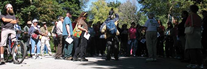
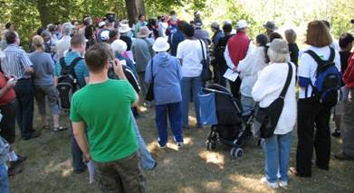
On Saturday, September 19, 2009, more than fifty participants gathered at Weston's Mallaby Park to begin the walk. Heritage Toronto's representative, Director Derek Boles, offered words of welcome.
Following this, Mary Louise Ashbourne, President of the Weston Historical Society, described how nomadic aboriginals established Toronto Carrying Place Trail. Consisting of a system of pathways and portages running more or less parallel to the Humber River over most of its length, the Trail was used to travel inland from Lake Ontario and to transport goods, including furs, dried fish, copper, and tobacco. French explorers and fur traders utilized the Trail from 1611 to 1793 to gain access to Lake Simcoe and the Great Lakes. Archaeological findings reveal that "portions of Riverside Drive, Humbercrest Boulevard, Weston Road in the Town of Weston area, and Pine Valley Drive follow the historic route." 2
At Weston's Humberview Crescent, Mary Louise offered a sympathetic insight into the lives and culture of the early aboriginals who hunted, fished, farmed, and traded in the Weston area. She revealed how the arrival of European fur traders and, later, settlers affected this way of life. "The British purchase of the lands in the Toronto area in 1787 marked the end of the European/Aboriginal fur trade. Lieutenant Governor John Graves Simcoe sailed into the Toronto harbour in 1793 and the milling era began." 3
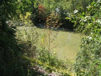
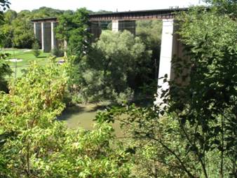
Participants were treated to a spectacular view of the Humber River from the high knoll behind Humberview Crescent. It was on the river flats, pictured above, that Weston's first mill was constructed. Dangerously high spring floods twice washed away the businesses clustered around the mill, forcing many to migrate to the already settled high ground on the east bank of the river. It was here, over time, that the Village of Weston came into being. The impressive bridge shown above was built about 1856 to service the Grand Trunk Railroad. Its original brick piers still stand, but were encased in cement some years ago to protect them from the elements. The metal superstructure has been replaced several times over the years. 4
Eva Ferguson, Treasurer of the Weston Historical Society, described the grist mill built here in 1815 by Joseph Holley, one of several that Holley designed and constructed along the Humber in and around the Weston area. The Farr brothers leased the grist mill from 1819 until 1828, whereupon brothers Charles and William Rein Wadsworth (after whom Weston's Wadsworth Boulevard is named) bought the lease, enlarged the flour mill and added a saw mill and distillery on the site. The sprawling mill complex is pictured below in a photograph supplied by the Weston Historical Society.
Photo courtesy of Weston Historical Society
The group was then led into the Humber River valley by means of a long wooden stairway, described by our guides as "solid as the Rock of Gibraltar". No souls were lost during the daring descent.
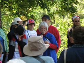
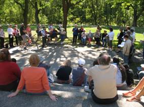
When everyone had assembled beside the river, Cherri Hurst, President of the Weston Heritage Conservation District, described the formation of the rich geological terrain surrounding the Humber. Cherri's wonderful article on this topic, Stories in Stone, is well worth investigating .
As Cherri spoke, the assemblage visualized a once tropical Weston, wracked by hurricanes, covered by an inland sea and inhabited by trilobites and plants identifiable today only by their fossilized remains. The layers of shale and siltstone created by these geological processes were to become a valuable resource. "Since the days of the early settlers, the Humber River shale has been used for foundations, walls and houses. One needed only a strong wagon, steady horse and a knowledgeable eye for the shape and colour of rock. The Town of Weston charged a fee of 75 cents a wagonload (1927) to haul the Humberstone from the river." 5
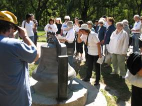 |
Further south, participants paused briefly to admire the cast brass bell that once adorned the belfy of Weston's Town Hall. It rang to warn of fires and bears the inscription “Lord, quench this furious flame. Arise, run, help put out the same. ”
When Dufferin Hall was razed (around 1959) the bell was relegated to storage. In 1967, as a Centennial project, the Weston Horticultural Society resurrected it, transported it to Cruickshank Park beside the river, and dedicated it to the memory of "the loyal workers of this community who provided junior horticultural programs."
|
|
Near the entrance to Cruickshank Park, Eva Ferguson spoke of the large sawmill, again built by Joseph Holley, that once dominated this site and she recounted the succession of owners, beginning with John Porter, who achieved prosperity through the operation of the mill. Weston's Cruickshank family ended up with the property and dismantled the mill in the late 1800s. The buildings were moved to Weston Road where they were used by Cruickshank Wagon Works. In 1928, Dr. Cruickshank donated the land to the Village of Weston to be used as a park. Over time, the Village acquired adjacent properties to create the long, contiguous green space that Westonites enjoy today.
|
 |
South of Lawrence Avenue, the group stopped at Lion's Park, another fabulous Weston resource.
Here, Barb Shiells, a Director of the Weston Historical Society, described the accidental 1911 unearthing of an aboriginal ossuary on the park's perimeter. "Archaeologists advised that the bones were part of a native burial ground and likely dated back to 1425-1450. It was the aboriginal custom, when they were moving on to establish a new village, to hold a sacred ceremony to show respect for their dead. They would gather the previously buried remains and re-inter them in one large pit." 6
|
In addition, Barb gave a colorful account of the Weston Fall Fair and Fairgrounds. "The annual fall fair was a popular two day event drawing people from miles around to participate in baking contests, crafts and needlework displays. One of the most exciting highlights of the fair was the horse races which drew huge crowds. The races ran on a half mile track which was oiled before to keep the dust down." 7
|
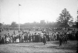
Photo courtesy of Weston Historical Society
|
The final stop of the day was at Raymore Park. It was here, on October 14, 1954, that thirty-two Weston residents died and more than a dozen homes were washed into the Humber River as a consequence of the violent flooding produced by Hurricane Hazel.
Participants viewed a memorial dedicated to those who perished in the storm. Some stepped forward to offer personal recollections of the event.
All in all, this was a very enjoyable and enlightening day. The Board of Directors of the Weston Historical Society deserves hearty congratulations for a well-researched and well-organized Fall Walking Tour. Copies of the Participants' Guide, produced by the Weston Historical Society for this walk, are still available in return for a modest donation to the WHS. If you are interested in obtaining one, please contact us at info@heritageweston.com
1 Toronto and Region Conservation Authority. The Humber River Watershed, http://trca.on.ca/protect/watersheds/humber-river/index.dot Accessed: 12/08/2009
2 From the Weston Historical Society’s Participant’s Guide, The Humber – An Urban Canadian Heritage River (Weston, September, 2009)
3 Ibid.
4 F.D. Cruickshank, and J. Nason,. History of Weston.(Weston: Weston Times and Guide, 1937), 145
5 WHS Participant’s Guide
6 Ibid.
7 Ibid.